![]()
![]()

The total mileage of this hike is about 2.5 miles, from the parking lot to the end of the Trail of Tears segment and back) It's mostly level ground, but there is a slight incline on a short section. The trail surface is a little rough in places and can be muddy after a rain, so it may not be suitable for strollers or children under 4 years old. You may want to take a water bottle. The only restrooms are at the picnic area.
From the entrance to East Fork Recreation Area, go about 0.32 miles to the parking lot at the picnic area (you will pass a parking area for the horse trail on your right). Park and walk towards the picnic area. You'll see a covered picnic shelter on your left. See the photo below:
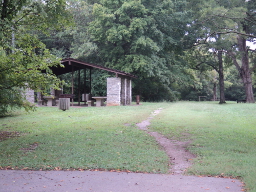
Follow the path that runs by this shelter towards the wooded area ahead, keeping the shelter on your left. You'll see a trail through the woods. See the photo below:
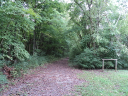
Follow this trail and after about 0.15 miles you'll come out of the trees at a gravel road. Turn to the right and you'll see the East Fork water treatment facility straight ahead. Follow the road as it turns left in front of the treatment facility. See the photo below:
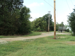
This gravel road is a continuation of Central Valley Road and this short section, to the point where it turns left in front of the treatment facility, follows the original Trail of Tears route.
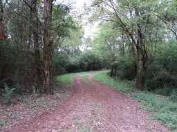
After the road turns left in front of the treatment plant, it begins to wind through the woods, becoming a dirt road (this is not part of the Trail of Tears route). See the photo below:
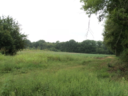
Continue following the road until you come to a cultivated field. See the photo below:
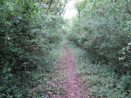
Turn to the right. At this point the road becomes a trail again and runs along the edge of the field for a short distance, then heads back into the woods with trees on both sides. Follow the trail for about 0.12 miles and the trail will make a sharp turn to the left. At this point you'll be on the Trail of Tears segment. See the photo below:
The segment continues for about 0.65 miles along the trail. At this point the original road veered off to the right towards the river. Currently there are no signs marking the end of the Trail of Tears segment, but look for a blue 2.5 mile marker on a tree that will be on your right (the distances on these markers refer to total distances on the horse trail - the mileage covered following our directions to the Trail of Tears segment will be less). See the photo below:
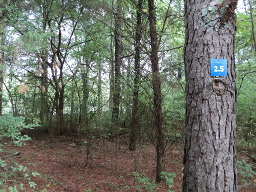
This mile marker is just beyond the end of the Trail of Tears segment. At this point turn around and follow the trail back the way you came.
Printable Version of Hiking Directions
Printable Map of Old Jefferson Site

